For the period of May 6-8, 2024, the Ozarks will have chances for severe thunderstorms.
Now that we are deeper into spring with less strong cold fronts with lesser ability to cool, dry and stabilize the central and southern U.S., all that is needed is a favorable jet stream pattern. This is what is forecast to develop early next week.
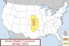
First Monday 5/6: the focus this day will be on the central Great Plains. The SPC forecast from this morning upped the probability of severe storms in parts of Kansas and Nebraska, an area already hit with spring storms lately:
For the Ozarks on Monday, the current thought is we will see whatever forms out west move into the area, implying that areas of western Missouri would have the better chance for some severe storms during the evening and overnight.
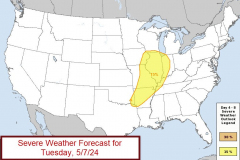
On Tuesday, the entire pattern shifts east. Model data this morning shows plenty of unstable air hanging out in Missouri. Currently, the risk area is as outlined below.
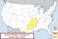
Moving on to Wednesday, the pattern stalls. The unstable air isn’t driven out by a cold front yet so the Ozarks find themselves in a threat area again.
Summary: unstable air and a favorable jet stream pattern through the three day period. Details depend on weather model changes and also what the previous day’s storms do. Stay alert! Updates coming often.
Storm chasing: I will be out in the Plains Monday and also try to chase “geo-friendly” areas on Tuesday and Wednesday.


