
There are presently two weather videos produced on a semi-regular basis:
Weather To Watch: Produced roughly every other day. Meant as a review of important, interesting or changeable weather over the lower 48 states.
Heads Up Weather: This is meant to focus on dangerous weather for the Ozarks. Produced on an “as needed basis”.
 Subscribe to my channel
1
/
12
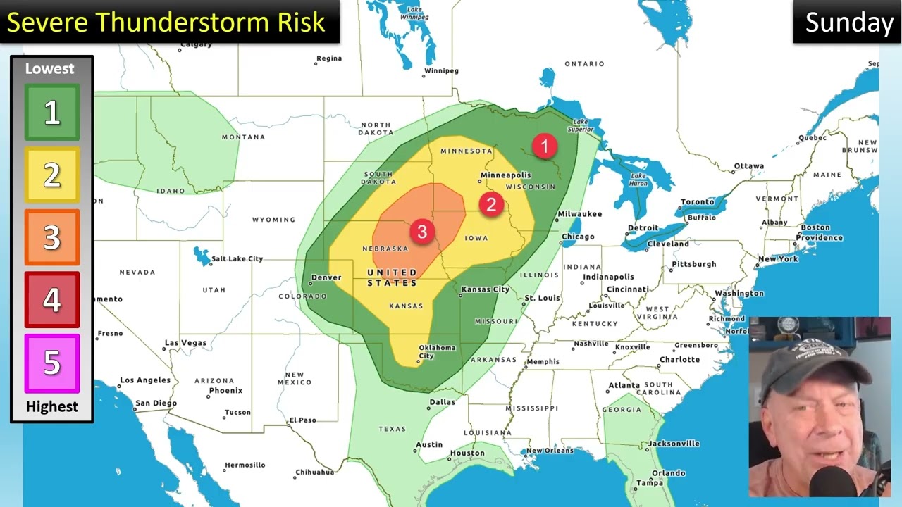
A slow moving front will produce many rounds of severe storms over the next few days.
Weather to Watch for the next 2 weeks! Active severe storm pattern. Hot weather shifting east.
Frost and freeze in the Great Lakes and NE. Fairly dry this week. Severe storm chances Saturday.
Severe storms in Texas. Frost and Freezing in the north. Heat slowing building and shifting/
Severe storms fading. Much of the country cool but heat slowly building in the west.
A progressive severe storm pattern. Frost and freeze concerns. Getting hotter out west.
Slow Moving Storm Producing Days of Severe Thunderstorms. Pockets of Heavy Rain. Repeating Pattern!
⚠A Weather Pattern Taking Shape Over The Next Six Days Will Bring Heavy Rain and Severe Storms⚠
Quiet For A Few Days. Rain and Storm Start Up Again This Weekend, Forecast to Persist!
⚡The Pattern Favors Multiple Severe Weather Days Ahead. 🌧Also Bands of Heavy Rain Will Set Up.
A Quiet Weekend But The Start Of April Will Be Wetter In Many Areas With Severe Thunderstorms Too.
Severe Storm Risk Ahead Next Cool Front. Mostly Warm & Dry This Week. Pattern Reversal Early April.
Extreme heat returning for many. Rain and storms later in the week. Pattern shift for early April.
🌧Prolonged Rain May Lead To Flooding! Patches of Severe Thunderstorms.
Pattern Reversal. More Rain Where Needed. Enhancement of Severe Thunderstorm Pattern.
1
/
12

1
/
8
Wind & tornadoes the main risk for the Ozarks. The line of severe weather will be late evening.
A small but measurable tornado risk for the Ozarks today!
"Heads Up" weather for the Ozarks. Slight risk for all severe hazards. OVERNIGHT STORMS possible.
⚠TWO VERY IMPORTANT UPDATES FOR SEVERE STORMS IN THE OZARKS!
Three things you need to know about upcoming severe weather chances in the Ozarks.
Heads Up Weather for the Ozarks. Severe Thunderstorm Threats Mid-Week and Again on Friday.
A line of severe thunderstorms will roll into the Ozarks this evening.
While threats for severe storms and heavy rain do exist, so far The Ozarks will miss the worst of it
SevereStorms Will Be Possible in the Ozarks on Wednesday. More Soaking Rain, Slight Flood Risk.
⚠Tornadoes Possible⚠ Evening Threat. I'll show simulated radar samples. Stay alert this evening!
⚠URGENT!⚠ Shift in placement and intensity of 🌪tornado threat🌪 for the Ozarks on Friday.
Be on alert for severe thunderstorms Friday! This will likely be a late evening/overnight event.
The Ozarks has a chance for storms on Wednesday and Friday. Several rounds of heavy rain are due.
A wetter pattern of weather will start Tuesday which may include severe storms.
❄❄MORE SNOW TONIGHT! Bitter cold, sub-zero morning ahead.
1
/
8